 宮古島アプリの綾道(あやんつ)トップページ
 宮古島アプリの綾道(あやんつ)の内容
 宮古島の3つのルート
 宮古島市長のあいさつ
 宮古島文化遺産紹介
Introduction to Cultural Properties
【Prefecturally Designated:Natural Monument (Fauna)】Miyako Sawa-Gani (Geothelphusa miyakoensis)

The Miyako Sawa-Gani is a native freshwater crab of Miyako Island. It has a carapace width of about 3cm, and is said to be closely related to the Osaw[…] read more – >
【Prefecturally Designated:Natural Monument (Fauna)】Miyako Uma Horse
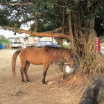
The Miyako Uma is a small-sized horse, with a height of about 120cm, and despite their large head, the rear of their bodies are insubstantial. They ha[…] read more – >
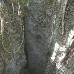
【Designated by the City:Historic Site】Nudogubiabu
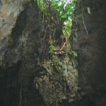
Nudogubiabu is located in a forest, 1.5 km southwest of Kanamaraabu.It is about 22 m deep and has two mouths. The larger entrance is 3 m wide and 25 m[…] read more – >
【Prefecturally Designated:Historic Site】Sumurya Myaka Tomb
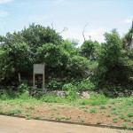
This is a large tomb belonging to the Sumurya (Nagama family) clan, located approximately 800m to the south of the Kurima settlement. In the long past[…] read more – >
【Designated by the City:Historic Site】Tauwainmiabu
Tauwainmiabu is located about 30 m inward from the roadside, which is about 50 m south of the T-intersection of the road between Pyazu Utaki (Kunmauky[…] read more – >
【Designated by the City:Historic Site】Usubariabu
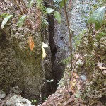
Usubariabu is diagonally across Kanamaraabu (at the northeastern side), which is located about 300 m north from the middle of Farm Road 78 in Nagayama[…] read more – >
【Prefecturally Designated:Historic Site】Ikeda-Bashi Bridge in Shimoji
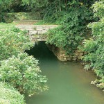
The Ikeda-Bashi Bridge is along the National Route 390 near the mouth of the Sakita River. It is said that the bridge was constructed with the Shimoji[…] read more – >
【Prefecturally Designated:Historic Site】Sacred Tamaishi Rock of Nobarudake
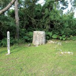
Located halfway up the mountain of Nobarudake on the south side, this sacred rock was originally placed on the northwestern side near the summit. The […] read more – >
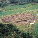
【Prefecturally Designated:Historic Site】Uipyayama Site
Located atop a Ryukyu limestone hill approximately 40m high at the south of the Sunagawa settlement, the site is from the 14th to the 15th century. To[…] read more – >
【Prefecturally Designated:Historic Site】Takausu-jo Castle Remains
This is the remains of a castle that was constructed at the summit section of a hill (113m high) located north of the Higa settlement on the east coas[…] read more – >